Celtie Ferguson, BA, PGC

Position
GIS Technician
Location
Aurora Research Institute (Inuvik)
Phone
867-777-3298 ext.241
Email
Celtie.Ferguson@auroracollege.nt.ca
dsc_1792

I was born in Yellowknife, although my family moved to Ottawa before I had a chance to experience the north, I had the desire to return as long as I can remember. My joy is found in wilderness spaces: I have been lucky enough to have had the opportunity to travel to Antarctica and have spent a month winter rafting in the Grand Canyon. A large portion of my work experience has been in remote or outdoor settings: at a camp on an island in Lake Huron, in the Columbia River Valley in British Columbia, and in Muskoka in Ontario. The skills these occupations have awarded me are diverse. I am a zip-line mechanic (in-training) and can captain small vessels!

At university I studied both Geography and Classics to support an interest in archeology. As an Archaeological Field Technician in Ontario I carried out archaeological surveys and excavations, delving into recording and preserving early European settlement and Aboriginal heritage. My post-graduate studies have furthered my interest in GIS and their relationship to environmental and resource management. I have a genuine interest in the Canadian North, and a GIS Technician, I am excited to gain more experience in cross-cultural processes and learn more about northern cultures and peoples.


Skills and expertise

I am skilled in georeferencing, digitizing, and spatial and statistical analysis. More specifically I am trained in ESRI ArcMap, PCI Geomatics, programming in Python with IDLE, as well as with open source and web-based applications. I work with both raster and vector data types, and have experience processing raw satellite imagery, aerial and UAV photography, and historical maps as sources of data and data collection. Additionally, I have worked with digital elevation models and interpolating surfaces, using statistical analysis to create predictive models. In creating map documents I pay mind to the principles of design and use of cartographic conventions.

List of current projects

  • Mineral Strategies GIS – Developing a Geographic Information System (GIS) to support the development and implementation of mineral strategies in the Western Arctic.
  • Community outreach and education on GIS through classroom visits in Inuvik and Ulukhaktok, hosting an event showcasing local occupations and applications of GIS and participation in the organization of other local 2018 GIS Day activities.

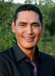
Greg Elias, Dip ENRTP

Position
Technician
Location
Western Arctic Research Centre (Inuvik)
Phone
867-777-3298 ext. 239
Email
Greg.Elias@auroracollege.ca
greg_elias_bio_pic

I’m originally from Sachs Harbour, NWT. I enjoy being outdoors, whether it’s camping, hunting, or working. I decided that I wanted to become a Renewable Resource Officer for the Northwest Territories Department of Environment and Natural Resources (ENR). As an ENR Patrolman, I would issue licences, permits, and wildlife tags – but the main reason I wanted to work for ENR was because of the wildlife. I enjoy working with wildlife; whether it’s deterring animals, regulating hunting, or handling samples. Sachs Harbour is a small community, and making sure wildlife regulations were followed was a big part of my work.

In 2012, I moved to Inuvik to enroll in the Environment & Natural Resources Technology Program (ENRTP) at Aurora College. I graduated in 2015, and was awarded the Governor General’s Award for Academics. Afterward, I moved back to Sachs Harbour, but am now back in Inuvik for field work this summer. I look forward to putting my education and experience to good use. 

Skills and Expertise

  • Field work in remote locations
  • Maintenance and inventory of equipment
  • Operation of motorized equipment (e.g. boats, skidoo, ATVs)
  • Sample collection
  • Data entry
  • Research assistance
  • Coordination of logistics
  • Coordination and implementation of safety protocols


Current Projects

  • Air Quality Monitoring – I provide technical support and troubleshooting for this project.  This includes calibrating air sensors, performing weekly checks of the monitoring equipment, and getting the station back online following service disruptions.
  • Permafrost monitoring – I collect data from permafrost monitoring stations, convert the data, and enter the data for analysis.
  • River water sampling – I collect river water samples from the Mackenzie and Arctic Red Rivers.
  • Pile infrastructure monitoring – I download data from nine loggers attached to five piles which continuously record the ground temperature at different depths.


Edwin Amos

Position
Senior Technician, Western Arctic Research Centre
Location
Western Arctic Research Centre (Inuvik)
Phone
867-777-3298 ext. 210
Email
Edwin.Amos@auroracollege.ca
edwin_photo-188x260

I’m an Inuvialuit Beneficiary of the Inuvialuit Final Agreement. I was born and raised in Inuvik, Northwest Territories. Over the years, I’ve gained a broad range of work experience that included heavy equipment operation, construction, painting, and the oil and gas industry. In 2013, I decided to change my career path to the environmental field. I graduated with honours from the Environment and Natural Resources Technology Program in 2015. During the program I worked as a Summer Student with ARI.

After graduation, I was hired as an Intern Technician, and since 2016, I’ve been a permanent Technician at ARI. My job allows me to work directly with scientists to conduct research. I enjoy getting on the land with the skidoos and boats to assist with research. It’s important to me to protect the land and animals in the western Arctic, so they’re available for future generations. This job helps me achieve that goal.

Education: Environment and Natural Resource Technology (Dip) 

Skills and Expertise

  • Field work in remote locations
  • Maintenance and inventory of equipment
  • Operation of motorized equipment (e.g. boats, skidoo, ATVs)
  • Sample collection
  • Data entry
  • Research assistance
  • Supervision of summer staff
  • Coordination of logistics
  • Coordination and implementation of safety protocols


Current Projects

  • Air Quality Monitoring – I provide technical support and troubleshooting for this project.  This includes calibrating air sensors, performing weekly checks of the monitoring equipment, and getting the station back online following service disruptions.
  • Permafrost monitoring – I collect data from permafrost monitoring stations, convert the data, and enter the data for analysis.
  • River water sampling – I collect river water samples from the Mackenzie and Arctic Red Rivers.
  • Pile infrastructure monitoring – I download data from nine loggers attached to five piles which continuously record the ground temperature at different depths.


Publications

  • M. S. Schwab, R. G. Hilton, P.A. Raymond, N. Haghipour, E. Amos, S.E. Tank, E.T. Tipper, and T. I. Eglinton. In Press. An aged carbon discharge event in Arctic Rivers associated with abrupt winter warming. Nature.

  • Behnke, M. I., McClelland, J. W., Tank, S. E., Kellerman, A. M., Holmes, R. M., Haghipour, N., Eglinton, T.I., Raymond, P.A., Suslova, A., Zhulidov, A.V., Gurtovaya, T., Zimov, N., Zimov, S., Mutter, E.A., Amos, E., and Spender, R.G.M. (2021). Pan-Arctic riverine dissolved organic matter: Synchronous molecular stability, shifting sources and subsidies. Global Biogeochemical Cycles, 35, e2020GB006871. https://doi.org/10.1029/2020GB006871

    Schwab, M. S., Hilton, R. G., Raymond, P. A., Haghipour, N., Amos, E., Tank, S. E., et al. (2020). An abrupt aging of dissolved organic carbon in large Arctic rivers. Geophysical Research Letters, 47, e2020GL088823. https://doi.org/10.1029/2020GL088823

  • Scott Zolkos, David P. Krabbenhoft, Anya Suslova, Suzanne E. Tank, James W. McClelland, Robert G.M. Spencer, Alexander Shiklomanov, Alexander V. Zhulidov, Tatiana Gurtovaya, Nikita Zimov, Sergey Zimov, Edda A. Mutter, Les Kutny, Edwin Amos, Robert M. Holmes. In Press. Mercury Export from Arctic Great Rivers. Environmental Science & Technology 2020 54 (7), 4140-4148  DOI: 10.1021/acs.est.9b07145

  • Amos E, Hille E, di Cenzo P, Wrona F, Paquette-Struger B. 2016. Impacts of Lake Ice, Shoreline Retrogressive Thaw Slumping and Fire on the Water Quality and Productivity of Small Tundra Lakes in the Northwestern Arctic. Poster presentation at the 2016 ArcticNet Scientific Meeting, Winnipeg, MB.


Garfield Giff, PhD, Dip Ed

Position
Manager, GIS Programs
Location
Aurora Research Institute (Inuvik)
Phone
867-777-3298 ext. 209
Email
Garfield.Giff@auroracollege.nt.ca
garfield_croped

Research Statement

Over the last twenty years, I’ve done extensive research and consulting work on the socio-political, socio-economic, and technical issues associated with the implementation and maintenance of Geographic Information Systems (GISs) and Spatial Data Infrastructures (SDIs). My research over the years has made significant contributions to the GIS/SDI body of knowledge in the following areas: economic justification of GISs and SDIs (e.g. cost benefit and cost avoidance analysis); funding models for the implementation and maintenance of GISs and SDIs; access and pricing policies for geospatial information; business models, strategic plans, program designs, and implementation plans to support GIS and SDI implementation and maintenance; quantification of the social and qualitative benefits of GISs and SDIs; frameworks for assessing GIS and SDI performance; and data models to support interoperability.

My current research focuses whether GIS and remote sensing can be used to develop and implement more efficient, effective climate change adaptation strategies in the western Arctic. I’ve been investigating the use of UAVs (unmanned aerial vehicles, or drones) to collect high volumes of data in a cost effective, timely, and reliable manner under the challenging conditions found in the western Canadian Arctic. If UAVs prove to be a reliable source of current, high-quality data, then this technology could be used to collect high volumes of information in a very reliable, consistent, and economical manner. This data would be more readily accessible and useful in developing climate change adaptation strategies in the western Arctic.

Click here to view my CV

Current Projects

  • Western Arctic Indigenous Mapping Workshops
  • ​Designing a GIS to Support the Development and Implementation of Mineral Strategies in the Arctic
  • Developing Online Digital Hazard Maps of Landslides Along the Caribou Hills, Inuvik, NWT
  • GIS and Remote Sensing Capacity Building in Indigenous Communities

Significant Contributions

  • Giff, G. 2013. Measuring and Monitoring Spatial Data InfrastructuresIn SDI Implementation Manual of the Americas. Chapter 10, (Eds.) GeoConnections; Hickling Arthurs Low Corporation; Giff, G.A. Permanent Committee for Geospatial Data Infrastructure for the Americas publication, UN, New York, pp.129-149.   
  • Giff, G. and Jackson J. 2013. Towards an Online Self-Assessment Methodology for SDIs. In Spatial Enablement in Support of Economic Development and Poverty Reduction. Chapter (Eds.) H. Onsrud and A. Rajabifard. GSDI Association Press, Needham, MA, USA, pp.99-120.
  • Giff, G. 2008. A Framework for Designing Performance Indicators for Spatial Data Infrastructure Assessment.  In A Multi-View Framework to Assess Spatial Data Infrastructures. Chapter Eleven, (Eds.) J. Crompvoets, A. Rajabifard, B. van Loenen, and T. Delgado Fernández. Space for Geo-Information (RGI), Wageningen University, Wageningen, The Netherlands, pp.211-228.
  • Giff, G. 2008. Using Performance Indicators to Assess SDIs/GISs. In Assessment and Socio-economic Aspects of Geographic Information Infrastructures. Chapter Two, (Ed.) B. van Loenen. The Netherlands Geodetic Commission, Delft, The Netherlands, pp.13-22.
  • Giff, G. et al., 2008. Designing Performance Indicators to Support Spatial Data Infrastructure Assessment. The Journal of Computers, Environment and Urban Systems Vol. 32, No. 5, pp 365-376.
  • Giff, G. et al., 2008. GI Policies in Norway and England; Are they Within the Spirit of Recent EU Directives? The International Journal of Spatial Data Infrastructure Research Vol. 3, pp 118-145.

Teaching Responsibilities

Teaching is not just lecturing to students, but is inclusive of the different methodologies for conveying theories, concepts, and empirical studies to students in a manner that facilitates the application of this information to solve problems related to their professional and daily activities. That is, teaching is the method of transferring information to students in a manner that will enable them to become critical thinkers. In summary, my teaching goal is to help students develop into highly critical thinkers. Achieving this goal will require the application of a variety of teaching strategies and a learning environment that promotes intellectual diversity.

  • ENRTP 120-116–Geographic Information Systems
  • Career and Technology Studies (CTS), East Three Secondary School—Introduction to CAD